By Giorgio Vacchiano, Sara Pelladoni, Lorenzo Rossi – University of Milan
Forests grow slowly. Every management choice, from thinning to planting, from harvesting to conservation, can influence their structure and functioning for decades. Until now, observing how trees grew in the past was a good enough blueprint to predict their future behaviour. However, the climate is changing so fast that foresters can no longer use the past as a reliable guide to the future. Rising temperatures, more frequent droughts and heatwaves, changing fire regimes, storms and insect outbreaks can alter growth, regeneration, mortality and species composition. A tree species that has performed well in a given area for centuries may become more vulnerable, while management systems designed for past climates may need to be adjusted. Field observations and local knowledge remain essential, but they now need to be combined with tools that can explore futures outside the range of what has already been observed.
Enter forest simulators. These tools help researchers and managers reproduce forest development inside a computer. They combine mathematical descriptions of ecological processes such as tree growth, competition, regeneration, mortality and disturbance to explore how a forest may change through time under different assumptions.
The basic idea is to run virtual experiments that would be too slow, costly or risky to carry out directly in real forests. A simulator can be used to ask what may happen if the next decades become warmer and drier, if fire risk increases, if harvesting intensity is reduced, if more deadwood is retained, if natural regeneration is favoured, or if tree species composition is diversified. Each option can be explored in different combinations over decades, making it possible to compare management strategies before they are implemented on the ground. This approach is central to FORbEST, because the project works on forests where carbon storage and biodiversity need to be preserved together.
One of the models used in FORbEST is iLand, a process-based forest model designed to simulate how trees and forests change year after year under different climates and management options. iLand represents processes such as growth of individual trees, competition for light and water, regeneration, mortality and disturbances, including fire. By combining these processes over time, the model can show how interactions among trees, species, climate and management choices can produce different forest structures and functions.
iLand works by combining climate scenarios and management scenarios. Climate scenarios describe possible future conditions, including temperature, rainfall and drought frequency, while management scenarios describe different choices, such as active management, close-to-nature forestry, restoration, protection or reduced intervention. By crossing these scenarios, researchers can grow the same forest many times inside the computer, each time under a different set of assumptions. The result is not a prediction with certainty, and forest simulators should not be interpreted as crystal balls. Their value lies in comparison, diagnosis and learning; simulations should run multiple times to leave room for the emergence of uncertainty, a core component of all natural processes, which may nevertheless be quantified and become part of the predictions. The answer that a simulator can provide is not how much carbon the forest will store in the year 2076, but rather what is the likely range of climate mitigation capacity of the forest in the 2070 decade under certain climate and management trajectories. For example, if several climate scenarios point to the same vulnerability, that signal deserves attention; if a management option performs well under many possible futures, it may be more robust; if one strategy increases carbon storage but reduces habitat quality, the trade-off becomes visible; and if an option works in one part of the landscape but fails in another, the model can help identify the mechanisms behind the difference.
Considering how trees and forests are arranged in space (their “landscape pattern”) is also very important to better understand their behaviour. Seeds disperse from parent trees up to a certain distance, and do not reach every place with the same probability; fires spread faster through certain types of vegetation, slopes and weather conditions; tree growth depends on neighbours, canopy gaps, soils and topography; and species are arranged across ridges, valleys, slopes, forest edges and stands with different histories. Models such as iLand account for these spatial dynamics, allowing researchers to analyse not only how much change may occur, but also where it may occur. This spatial perspective can help identify forests that may become more vulnerable, areas where regeneration could fail, parts of the landscape where fire could spread more easily, and zones that may contribute more to carbon storage, habitat continuity or ecological resilience. In this way, modelling can support decisions about where management is most needed, where protection may be most effective, and where different objectives may come into conflict – what ultimately represents the core aim of forest planning.
For FORbEST, iLand and related modelling tools can contribute to estimating future carbon stocks and carbon uptake, exploring changes in forest structure, species composition, deadwood and disturbance regimes, and providing indicators for biodiversity assessments and decision-support tools. They will describe the range of potential conditions for future habitat, feeding other modelling tools with the information needed to understand how this habitat will be use and by whom. They can also help transform field data and ecological knowledge into maps, indicators and scenarios that can be discussed with forest managers, protected area staff, policymakers and local communities.
The first pilot area for this modelling work will be Sila National Park in Calabria, southern Italy, a landscape where forests of high conservation value, long management history and exposure to climate-related pressures coexist.
Using iLand does not make forest management automatic, nor does it remove the need for political choices, local knowledge and field expertise. It makes assumptions explicit, shows possible consequences and helps test ideas before they become interventions. In a time when looking only at the past is no longer enough to plan for the future, forest simulators can help us manage real forests with more evidence and less improvisation.
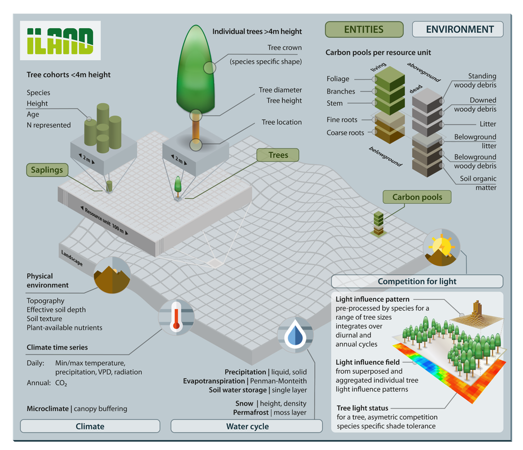
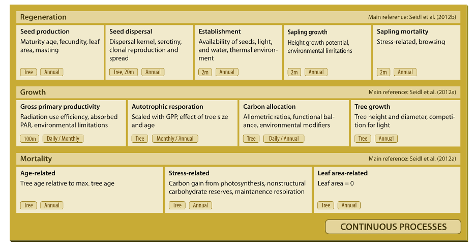
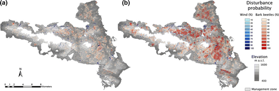
Below are three figures that provide context for those new to iLand. Figure 1 provides an overview of the specific forest “entities” modelled within the iLand simulation space. Figure 2 shows how three core forest processes are continuously simulated within iLand. And Figure 3 is an example of iLand prediction maps generated to inform forest planning concerning future forest disturbances in a warmer climate.